What is inside the ESA Ocean Synergy Training Course 2025 (#OTC25)
Ocean and atmosphere dynamic processes define the surface expressions imprinted on the sea surface or in the atmosphere that we can measure from space. In order to extract scientific knowledge from satellite data, it is fundamental to understand the processes that define the signals we can measure. This is at the very heart of the #OTC25 which has the following course aim:
To understand and interpret the ocean signatures that are measured from complementary satellite instruments in space by studying the sensor physics used to measure ocean signals and the fundamental ocean and atmosphere processes that define those signals.
The best place to do this is on the ocean surface itself which is why the #OTC25 Training Course consists of two mandatory parts:
Ship-based component

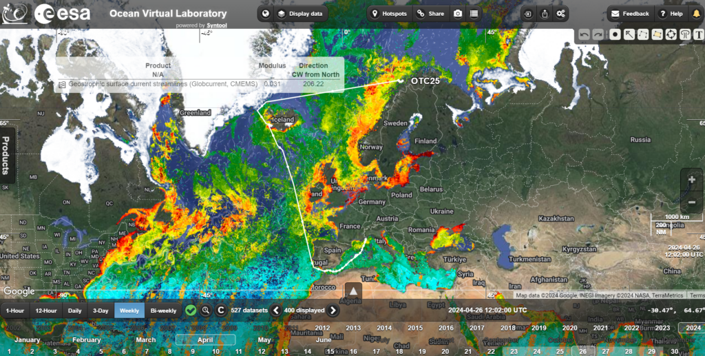
A ship-based component aboard the tall ship Statsraad Lehmkuhl (https://lehmkuhl.no/en/) during the One Ocean expedition from Tromø, Norway, to Nice, France, via Reykjavik, Iceland (see draft voyage track here). During this part the One Ocean Expedition we will depart Tromsø on 22nd April 2025 to sail 6200 nm in about 35 days arriving in Nice, France on 4th June 2025 as part of the opening events for the United Nations Ocean Conference 2025.
We will offer an advanced training course in satellite oceanography in support to Marine Services tailored to regional environmental and climate change of the oceans in the Norwegian Sea and Northeast Atlantic Ocean. During the voyage, you will collect in situ observations and use these together with satellite data and ocean model outputs to interpret the ocean state, validate satellite and model data and conduct your own research following your own proposed research plan. Being at sea (https://lehmkuhl.no/en/life-on-board/) is the best place to understand the origin of the signals we measure from space!
Shore-based online component

A shore-based online component that consists of 14 modules that are run once per week for a duration of 2 hours each. Each module will explain a different Earth Observation satellite measurement: how they work, how different instrument measure different parameters, and how we can apply derived data in different ways for ocean science applications. The shore-based course will focus on a virtual Voyage of the ship-based component of the training course.
A broad range of disciplines will be covered in satellite oceanography, upper ocean dynamics, air-sea interaction, coupling of ocean physics to biogeochemistry, marine biology, ocean modelling and data assimilation, and environmental and climate change. It will both give the students background knowledge of the content and use of the portal as well as offer opportunities to select specific analyses options that may be well aligned with graduate studies and thesis subject. As an example, you can access all of the ESA 2023 Training course materials and recorded lectures here.
Requirements: you will need a computer that you have download rights for, plus a good internet connection. The proposed day for the course is Wednesday Afternoons starting 3rd December 2024 until the 12th April 2025, running from 16:00 – 18:00 CET. Lectures will be recorded and made available online in case on any missed lessons.
Both the introductory virtual training course and the onboard training course on Statsraad Lehmkuhl will be run by internationally recognized expert lecturers. A report from each student is required based on the results obtained following student personal research proposals and related studies using the data collected aboard the ship and from satellite measurements. The delivery of reports by 1st October 2025 is mandatory to be granted ESA Training Course Diploma to be awarded in 2025.
Indicative route of the Tall Ship Statsraad Lehmkuhl during the #OTC25 voyage. The map shows a 2-weel composite of Chlorophyll-a derived from Sentinel-3 Ocean and Land Colour Instrument (OLCI, https://sentiwiki.copernicus.eu/web/s3-olci-instrument) using the OC4ME algorithm (for a review of different algorithms see https://www.sciencedirect.com/science/article/pii/S0034425716304515).
Satellite measurements of our ocean from space have revolutionised how we see the ocean – from the first ocean colour images of the Coastal Zone Color Scanner (CZCS) revealing biological ocean structures within a highly complex and dynamic mesoscale surface circulation – to the operational Sentinel-3 Ocean and Land Colour Imager (OLCI) – that underpin hourly weather and ocean analyses and forecasts that we use every day. The oceans from space are truly astounding when we look using different coloured Earth observation “spectacles”: radar measurements of surface roughness, thermal measurements of ocean surface temperature, visible measurements of ocean colour revealing the rich biological systems of our upper ocean, or measurements of ocean surface salinity using microwave radiometry. There is a vast amount of satellite data available over the oceans which is included in the Ocean Virtual Laboratory allowing you to fly around the world and investigate the global ocean at any time which can be accessed at https://ovl.oceandatalab.com/.
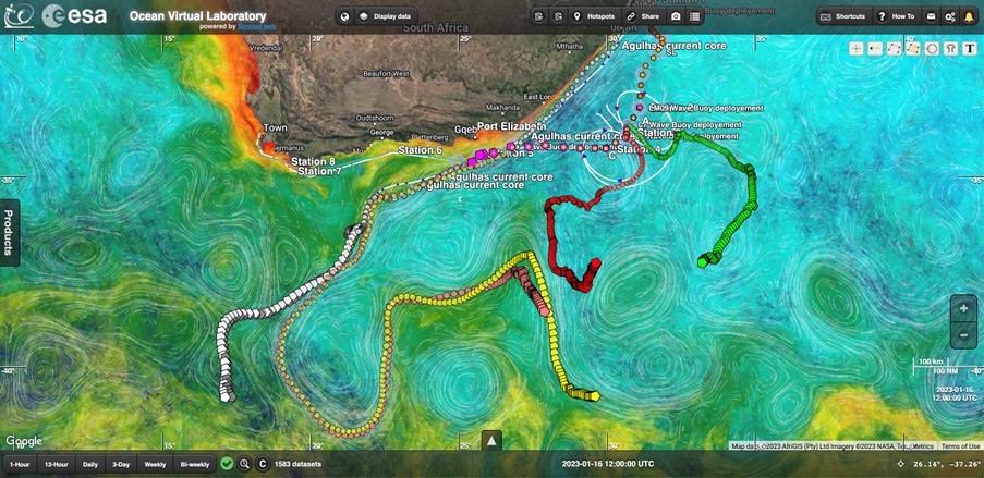
Trajectory of surface wave drifting buoys deployed during the ESA Ocean Training Course in 2023 highlighting the complex dynamics of the Agulhas current retroreflection. (See Ocean Virtual Laboratory (oceandatalab.com))


